


The Old Indian Boundary

The Old Indian Boundary
Hello, everyone, and welcome to the return of Canal Stories, a series brought to you by the Canal Corridor Association celebrating the Illinois and Michigan Canal and the communities that were shaped by its legacy. The role of the Illinois and Michigan Canal in the development of the nation has longed been ignored as it has been encapsulated in the broader story of the Market Revolution under internal improvements. This article is brought to you by Wayne Duerkes, PhD.
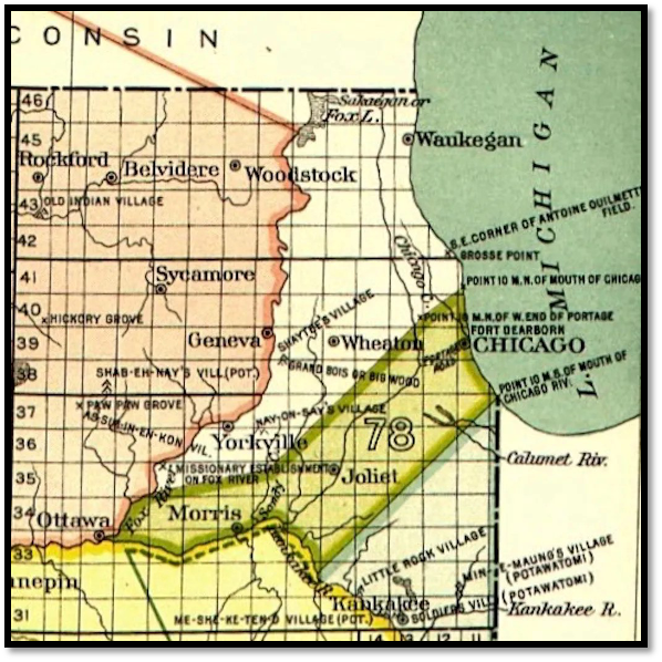
“A Treaty of Peace, Friendship, and Limits…” is the name of the treaty between the commissioners of the United States of America and representatives of Ottawas, Chippewas, and Pottawatomies on August 24, 1816. With this peculiar-sounding treaty, the fourteen tribal leaders collectively gave up the rights to one of the most important pieces of land in the entire Midwest. The U.S. government secured a pathway for the idealized future canal with this irregular shaped stretch of land. As the map inset shows, the path from the south branch of the Chicago River, to the Des Plaines River, and onward to the Illinois River was clear for Anglo settlement and development.
This treaty worked in conjunction with the infamous St. Louis Treaty of 1804, when the U.S. government, under future president, William Henry Harrison, secured the rights to most of northwestern Illinois from the Mesquakie and Sac tribes. It was this treaty that later acted as a catalyst for the conflict referred to as the Blackhawk War; as it was signed under false pretenses by a tribal delegation who were not authorized to act on the tribes’ behalf for land negotiations, but rather to obtain the freedom of their fellow tribesmen under arrest in St. Louis. Similarity, to finalize the trifecta of future canal land sessions, in September 1818, government commissioners obtained the land rights for the land south of the Illinois River. This treaty, with the Peoria, Kaskaskia, Mitchigamia, Cahokia, and Tamaroa tribes came through just a few months prior to Illinois statehood. Throughout the era, the United States and the various tribes signed several additional treaties that overlayed existing treaties to further entrench Anglo rights to the land. The phrase ‘rights to the land’ had different meanings to the two parties and the interpretation of that meaning caused contention and hostilities between the belligerents.
The U.S. government exacerbated the issue of future fighting by a combination of treaty provisions and initial lackadaisical enforcement. The land covered by the Treaty of 1816 is an important example. In Article 2 of the treaty, the government allowed fishing and hunting within the old Indian boundaries for the individual tribes. To the various tribes, this was interpreted as the same access as before the treaty. This was generally inconsequential as the entire northern section of the state was sparsely populated by Anglo people. This, in turn, kept interaction between the two groups to a minimum and the meetings that did occur were usually based on commodity exchange. As a result, the need to have army or militia units in the region were not of national importance nor were they economically feasible either. But, the anticipated canal—which became an official plan in 1826—hastened the need for tribal displacement. As more settlers poured into the region seeking new lives and economic fortunes, the confrontations between the new residents and their Indian neighbors escalated. As such, enforcement of the land cession between the old Indian boundaries increased, so that the canal could be planned and the adjoining land sold and settled.
The Anglo perception of land is based on ownership and that can only be achieved through the process of surveying. Surveying created an invisible line around a piece of property that delineated one owner’s land from their neighbors. The initial process of surveying included blazing trails through timber, making mounds of rocks, and other marks so that new settlers can visualize their new purchase. Indians knew what these markings meant; and attempted to disrupt the process whenever they could. Because the young state of Illinois, as well as the federal government, were partners in the planned canal, surveying focus was initiated within this canal zone established by the Treaty of 1816. As further settlement in northern Illinois flourished, counties, townships, and villages were platted around the old Indian boundaries. For a time, regional settlers had to contend with both the government’s cadastral surveys and the existence of tribal lands. In many early governmental surveys and in county plat books, the old Indian boundary survived as a demarcation of the before and after of the Treaty of 1816.
The State of Illinois, as well as other local municipalities, have recognized the boundary and what it stood for in our nation’s history. The relationship between the canal and local tribes are inextricably linked and we cannot truly understand the broader history of either without the other. The United States has grown into the nation it is today due to the vision of our settlers and the great losses inflicted on the Indian tribes.
That concludes today’s Canal Story. Thank you so much for joining us as we continue our journey through the history of the Illinois & Michigan Canal. If you have enjoyed this episode, pass it along to your family and friends, be sure to leave us a like or drop us a comment, and we will see you again very soon.